BROOKINGS MARATHON
  • Registration
  • Marathon
    • Race Information
    • Course Information
    • Support & Amenities
    • Awards & Records
    • Results
    • Training Resources
    • Travel & Hotel
    • Directions
    • Race Week Schedule
    • Weather
  • Half Marathon
    • Race Information
    • Course Information
    • Support & Amenities
    • Awards & Records
    • Results
    • Training Resources
    • Travel & Hotel
    • Directions
    • Race Week Schedule
    • Weather
  • Marathon Relay
    • Race Information
    • Course Information
    • Support & Amenities
    • Awards & Records
    • Results
    • Training Resources
    • Travel & Hotel
    • Directions
    • Race Week Schedule
    • Weather
  • 5K
    • Race Information
    • Awards & Records
    • Results

Course Information

The Annual Brookings Marathon is a Boston qualifier, USATF Certification #SD20001MN (Marathon) and #SD18001MN (Half Marathon).

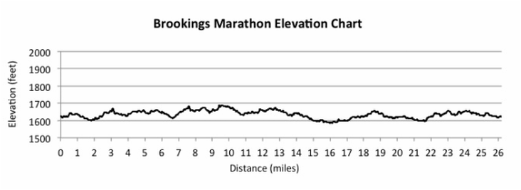
Our course takes runners through the best rural America has to offer: parks, gardens, bike paths, historic districts and South Dakota State University.

The course is flat, with a gentle grade thrown in here and there to keep things interesting. With the exception of Larson Hill (a 35' high hill that you could walk up and down in a minute) the entire course stays between 1595 and 1680 feet of elevation and never changes more than 40 feet over a single mile.

Because our course traverses the entire city, closing roads during the race would result in frustrated motorists and an increased safety risk. Accordingly, roads are open during the race, with volunteers controlling traffic at major intersections. Traffic in Brookings is light on a Saturday morning, but as in any road race, you are ultimately responsible for your own safety. Use of headphones and other devices that could distract you from traffic is discouraged. In the interest of runner safety, dogs, bikes, strollers and rollerblades are not allowed on the course.

The marathon course is open (water, first aid, traffic control provided) based on a 6 hour pace and the half marathon on a 3 hour pace (13:45 per mile). Participants who are proceeding at a rate slower than this pace may be asked to leave the course for their own safety.

TOP ^


Course Map

Download the Brookings Marathon, Half Marathon and Marathon Relay Course Map in PDF format.


Picture
VIEW MAP

TOP ^


Course Elevation Chart

Picture

TOP ^


Course Commentary

Miles 1-2
  • Well protected, established trees all around.  Flat but a few turns.  At the one mile marker down to Western Ave, there will be a very gentle downhill (note, course varies in elevation about 100 feet start to finish).

Mile 2-3
  • At Sexauer Park, there will be a short stretch on firm grass.  A small, narrow bridge crosses a creek here.  Gentle uphill to SDSU campus.  A little more open here, could have some wind if out of the north.

Miles 3-5
  • Through campus and around McCrory Gardens, fairly well protected. 

Miles 5-8
  • Back through main part of town.  Well protected and little elevation change.

Mile 8-9
  • Gentle downhill to Larsen park and mile marker nine.  Here is the base of the biggest hill on the course.  Rises about 35 feet in a 200 yard stretch.  On the back side of the hill is a fairly quick but short downhill stretch.

Miles 9-11
  • Minimal elevation change, again through established trees and in town. Half marathoners split off at approximately 10.5 miles and head back to Pioneer Park.  Marathoners will go under the railroad tracks through a viaduct.  Quick down and up, shouldn't be too noticeable.
​
Miles 11-13
  • Through town, no significant changes to Mile 13.  Once to the bike path, all smooth asphalt.

Miles 13-14
  • Bike path with gentle rolling hills.  Most troublesome would be wind out of the south, but do have some protection along much of this stretch.

Miles 15-16
  • The Nature Park has been incorporated into the marathon course.  Replaces the short gravel stretch near the interstate.  The bike path winds through beautiful ponds and abundant trees.  A great place to mentally recharge.

Miles 17-20
  • Gentle rolling hills, slightly up.  Not much wind protection.  The long stretch along 12th Street just before mile marker 20 should allow view of participants ahead or behind you.

Mile 20-22
  • Very gentle uphill, continuing through Half Moon Road.

Mile 23
  • All of the paths here pass under roads, fairly well protected.  From Council Ridge Rd to the water station is a fairly brisk rise of about 50-60 feet.  Also enough curves that you can't see too far ahead.  From the water station to Western Ave is downhill.

Mile 24-25
  • A little more exposed, at least to mile marker 25.

Mile 25-26
  • No significant elevation changes.  Well protected back to Pioneer Park.

TOP ^

Course Map

Course Elevation Chart

Commentary
Picture
Contact  
FAQs  
Volunteer  
Sponsors
Facebook
Twitter
Next Race Date: Saturday, May 13, 2023
  • Registration
  • Marathon
    • Race Information
    • Course Information
    • Support & Amenities
    • Awards & Records
    • Results
    • Training Resources
    • Travel & Hotel
    • Directions
    • Race Week Schedule
    • Weather
  • Half Marathon
    • Race Information
    • Course Information
    • Support & Amenities
    • Awards & Records
    • Results
    • Training Resources
    • Travel & Hotel
    • Directions
    • Race Week Schedule
    • Weather
  • Marathon Relay
    • Race Information
    • Course Information
    • Support & Amenities
    • Awards & Records
    • Results
    • Training Resources
    • Travel & Hotel
    • Directions
    • Race Week Schedule
    • Weather
  • 5K
    • Race Information
    • Awards & Records
    • Results